We are pleased to announce the availability of PERGOS-3, Oceanweather's (OWI's) follow-up to the PERGOS and PERGOS-2 metocean hindcasts for the Persian Gulf. This continuous hindcast archive spans the period 1960 through 2024 and has been produced using our decades of experience in atmospheric reanalysis and ocean response modeling in the region. For the hindcast, the ADCIRC+SWAN modeling system was implemented in the relatively shallow Gulf domain to capture tidal and storm surge water level variation and incorporate it in the wave model response. Wind, pressure, bulk wave, water level and current parameters are available as time series at individual points in addition to available operability and extreme value analyses.
Archive Time Step: 1-hour
Hindcast Period: 1960-01-01 through 2024-12-31 (continuous)
Variables: Met., Wave and Hydro.
Spatial Resolution: 500m-6km (unstructured mesh)
Latitude Coverage: \(23.14^{\circ}\) to \(30.5^{\circ}\) N
Longitude Coverage: \(47^{\circ}\) to \(56.4^{\circ}\) E
Met. forcing: ERA5 with statistical corrections and kinematic analyses
Tidal boundary: TPXO9 forced from the Gulf of Oman
OWI are pleased to announce the availability of West Africa Normals and Extremes (WANE4), our latest publicly available hindcast for the West African coastline. This hindcast was designed to be an improvement over other available wind and wave datasets including ERA5 and our own previous WANE products.
These hindcast data consist of continuous hourly time steps of wind and wave parameters from 1979 through 2024, with yearly future updates. Full 2D frequency-directional wave spectra are also available along the entire coastline at a subset of archive locations. These data are suitable for a variety of uses in the metocean and offshore design fields, and are available for purchase by point or as a whole and in a variety of formats including statistical analyses.
Oceanweather Inc. (OWI) is pleased to once again exhibit at the Offshore Technology Conference (OTC) in Houston, May 5-8th 2025 at NRG Park. This is OWI’s 27th year as an exhibitor. Please visit OWI at Booth 2321 in NRG Center.
Oceanweather Inc. (OWI) would like to announce that effective January 1st, 2025, Vice President Erin Harris has succeeded Andrew (Andy) Cox as company President. Andy Cox is eager to continue working as a president emeritus focused on research projects, and his new advisory role. He has served as President since 2013 after the passing of founder Dr. Vince Cardone, during which time he demonstrated commendable leadership of the company and its employees. We are proud of his accomplishments during his tenure and his continued commitment to the longevity of the company.
Erin Harris started her career at Oceanweather in 2003 as an intern. In 2007, she took the lead as speculative products manager, and in 2020, succeeded Brian Callahan as Vice President.
Project Manager Alex Crosby will replace Erin as Vice President of Oceanweather, while continuing his work as an Ocean Engineer. Alex joined OWI in 2014.
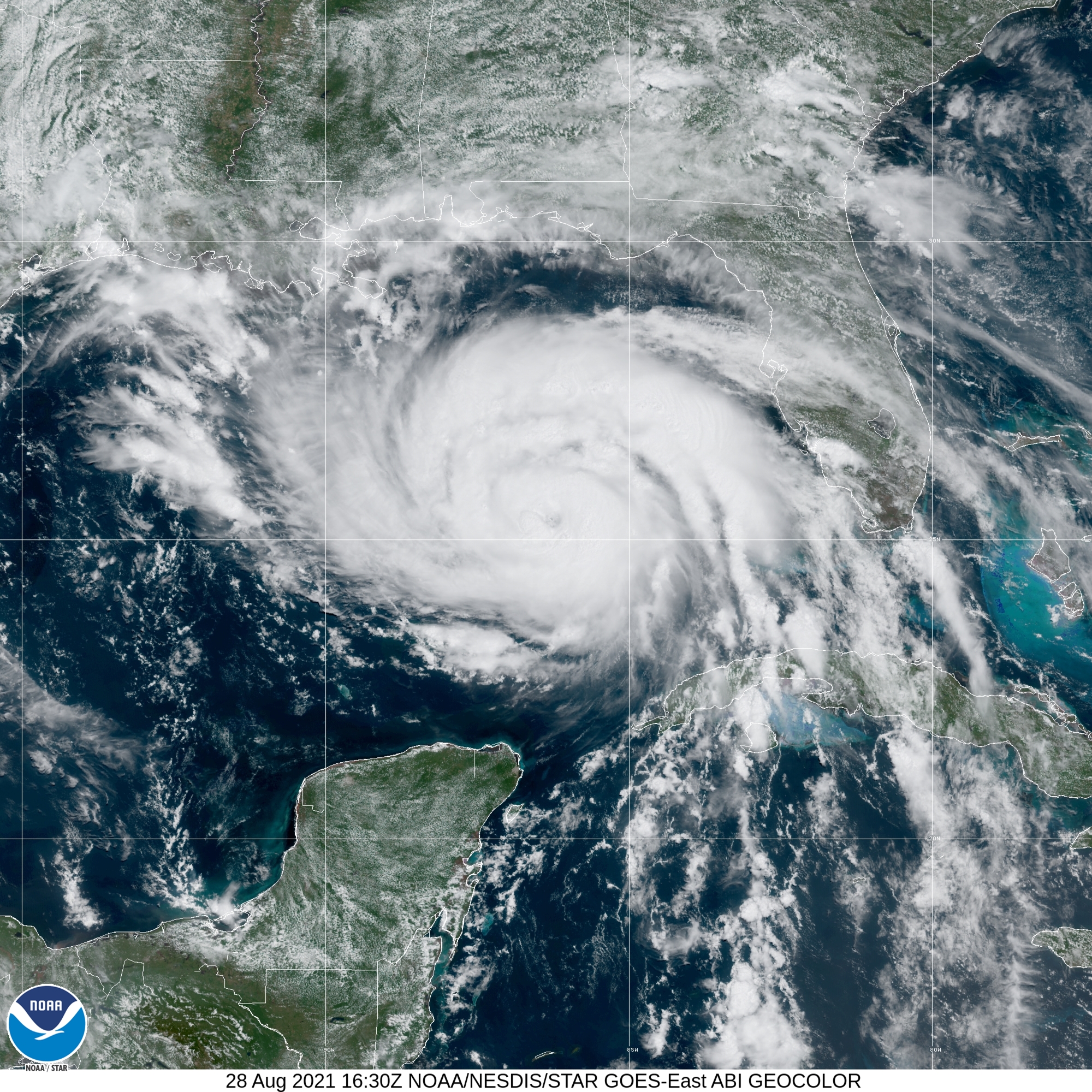
Oceanweather (OWI) have recently completed short-term hindcast reanalyses of hurricanes Helene and Milton, from which data products are now available. OWI routinely produces “fast-response” tropical cyclone hindcasts for significant storms in order to support hurricane recovery activities and to improve future resiliency. Detailed reanalysis of the conditions experienced in a strong offshore and/or land-falling hurricane are essential for accurate ocean response modeling designed provide critical guidance on the extent of the storm wave and surge inundation. Wind, pressure, and/or OWI’s standard bulk wave parameter fields or timeseries for these events are available.
GOES satellite image of Hurricane Milton approaching landfall in Florida with the corresponding NHC forecast and warnings. (NOAA, NHC & OWI)click through to read more...
In order to support hurricane recovery activities and to improve future resiliency, Oceanweather (OWI) routinely produces “fast-response” tropical cyclone hindcasts for significant storms and has started work on recent 2024 hurricane Beryl. A detailed reanalysis of the conditions experienced in a land-falling hurricane are required in any ocean response modeling to provide critical guidance on the extent of the storm wave and surge inundation. OWI can provide wind, pressure, and/or OWI’s standard wave fields for these events.
As experts in providing meteorological forcing for ocean response modeling of extreme wind, wave and storm surge events, OWI has a long history of quickly responding to the need for hindcasts of recent or active tropical events. This expertise is also applied in long-term operational and storm hindcasts in public and private sectors around the globe.
GOES satellite image of Cyclone Beryl approaching the Windward Islands and Caribbean Sea (NOAA)click through to read more...
Oceanweather Inc. (OWI) is pleased to once again exhibit at the Offshore Technology Conference (OTC) in Houston, May 6-9th 2024 at NRG Park. This is OWI’s 26th year as an exhibitor. Please visit OWI at Booth 2331 in NRG Center.
Oceanweather is pleased to once again attend Oceanology International 2024 at the ExCel Center in London, March 12-14. Please visit us at booth A105 if you are attending OI2024. We look forward to seeing you!
At OWI, we have opened-up some of our internal Python to read our WIN/PRE ascii formats, which are referred to as OWI or NWS12 files by the ADCIRC modeling community.
The code is broken up into the following components:
These components have been assembled into a Docker container image with the Dockerfile and repository available on Gitlab as well. This container image has the required publically available Python dependencies already installed, and running from Docker will execute the winpre_to_nws13.py script.
Subject: Oceanweather are pleased to be back at the Offshore Technology Conference (OTC) in Houston, 1-4 MAY 2023 at NRG Park. This is OWI’s 25th year as an exhibitor. Please visit Oceanweather at Booth 2331 in NRG Center.
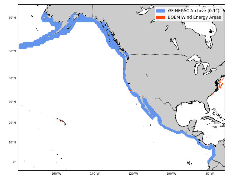
Announcing GROW-FINE NEPAC (GF-NEPAC) our latest publically available hindcast for the Pacific coastlines of North and Central America, encompassing Alaska’s Aleutian Islands in the North to the middle of Ecuador’s mainland coastline in the South. This hindcast was designed to be an improvement over other available coastal Pacific wind and wave datasets including ERA5 and our earlier NEPAC products.
These hindcast data consist of continuous hourly time steps of wind and wave parameters from 1979 through 2021, with 2022 to be added soon. Full 2D frequency-directional wave spectra are also available at a subset of the 0.1° (6-minute) resolution coastal grid, while bulk wind and wave parameters have been archived at each grid point. This archive grid extends from the coastline out into deep water incorporating (at least) the offshore 1000 m depth contour. These data are suitable for a variety of uses in the metocean and offshore design fields, and are available for purchase by point or as a whole and in a variety of formats including statistical analyses.
In order to support hurricane recovery activities and to improve future resiliency, Oceanweather (OWI) routinely produces “fast-response” tropical cyclone hindcasts for significant storms and has started work on the extremely destructive 2022 hurricane Ian. A detailed reanalysis of the conditions experienced in a land-falling hurricane are required in any ocean response modeling to provide critical guidance on the extent of the storm wave and surge inundation. OWI can provide wind, pressure, and/or OWI’s standard wave fields for these events.
As experts in providing meteorological forcing for ocean response modeling of extreme wind, wave and storm surge events, OWI has a long history of quickly responding to the need for hindcasts of recent or active tropical events. This expertise is also applied in long-term operational and storm hindcasts in public and private sectors around the globe.
Validation of ADCIRC water levels based on OWI's Hurricane Ian surface wind forcing reanalysis (Provided by Dr. Joannes Westerink, Computational Hydraulics Laboratory at The University of Notre Dame)click through to read more...
Oceanweather (OWI) is pleased to announce the launch of the North European Wave Study (NEWS) Joint Industry Project (JIP) for the offshore oil and gas areas in the North Sea, Norwegian Sea, Barents Sea and offshore UK. The study is currently underway and addresses the continuous period 1979-2021 with application of detailed kinematic analysis of storm winds in over 150 events to develop a new 43-year wind and wave archive suitable for both operability and design.
Oceanweather Inc. (OWI) was formed in May 1977 as a small business and established an office in White Plains, NY. The original principals in the company, Dr. Vince J. Cardone, Dr. J. Arthur Greenwood and Ms. C. V. Greenwood, had worked together on federally sponsored research programs at New York University and the City University of New York where Dr. Cardone was Associate Professor of Meteorology and Oceanography.
Oceanweather is pleased to once again attend Oceanology International 2022 at the ExCel Center in London, March 15-17. Please visit us at booth A20 if you are attending OI2022. We look forward to seeing you!
Oceanweather (OWI) is pleased to announce the launch of the Newfoundland Offshore Meteorological and Oceanographic Study Joint Industry Project (NEWMOS JIP). Phase 1 will launch in January 2022 and address the top tropical and extra-tropical storms from the period 1979-2021 by applying detailed kinematic analysis of storm winds and application of a ~4 km spectral ocean model. Phase 2 of the study (expected start June 2022) will model the full continuous period to develop a 43-year database of winds and waves for operability and design.
In order to support hurricane recovery activities and to improve future resiliency, Oceanweather (OWI) routinely produces “fast-response” tropical cyclone hindcasts for significant storms and has started work on the damaging 2021 hurricane Ida. A detailed reanalysis of the conditions experienced in a land-falling hurricane are required in any ocean response modeling to provide critical guidance on the extent of the storm wave and surge inundation. OWI can provide wind, pressure, and/or OWI’s standard wave fields for these events.
As experts in providing meteorological forcing for ocean response modeling of extreme wind, wave and storm surge events, OWI has a long history of quickly responding to the need for hindcasts of recent or active tropical events. This expertise is also applied in long-term operational and storm hindcasts in public and private sectors around the globe.
GOES-East satellite view of Hurricane Ida as it strengthens in the Gulf of Mexico before making landfall in Louisiana. (Provided by NOAA).click through to read more...
Oceanweather is pleased to announce an update to GOMOS (Gulf of Mexico Oceanographic Study) for the years 2018-2020 in a version of the hindcast called GOMOS2020. This brings the total number of Tropical events to 442 and Extratropical events to 131, and it brings the continuous operational period up to 41 continuous years.
Oceanweather Inc. (OWI) is pleased to announce the availability of our second-generation South East Asia Fine hindcast (SEAFINE-2) using new wind forcing and a unified grid setup for the period 2015-2019. This hindcast includes a continuous hindcast as well as detailed modeling of all South China Sea (SCS) tropical cyclones and monsoon events.
The hindcast effort includes the analysis and detailed modeling of all tropical cyclones in the SCS from 2015-2019 as well as reanalysis of significant Southwest and Northeast monsoon events. The hindcast has been extensively validated using industry collected measurements as well as publicly available buoys and data from satellite based altimeter, radiometer, and scatterometer observations.
Modeling tropical cyclone winds with accuracy is a critical step in generating proper wave and surge responses. High resolution tropical wind solutions that can yield eyewall details will provide more accurate surface forcing fields for downstream ocean response modeling systems. Global forecast (and hindcast) models are limited in spatial scale resolution and physics to simulate the detailed wind fields needed for ocean response models. Oceanweather (OWI) runs a proprietary in-house tropical planetary boundary layer model (OWITropPBL) which produces detailed high resolution winds that can be integrated into global or regional surface forecast wind fields.
Oceanweather Inc. (OWI) and DHI are happy to announce expanded pricing and data packages for the PERGOS-2 hindcast. New options include continuous (operational) timeseries and/or statistics for 20, 10, 5, and 1 year in addition to the standard full period 1979-2018 (40 years). For more information, please email Erin Harris at erinh@oceanweather.com for further information.
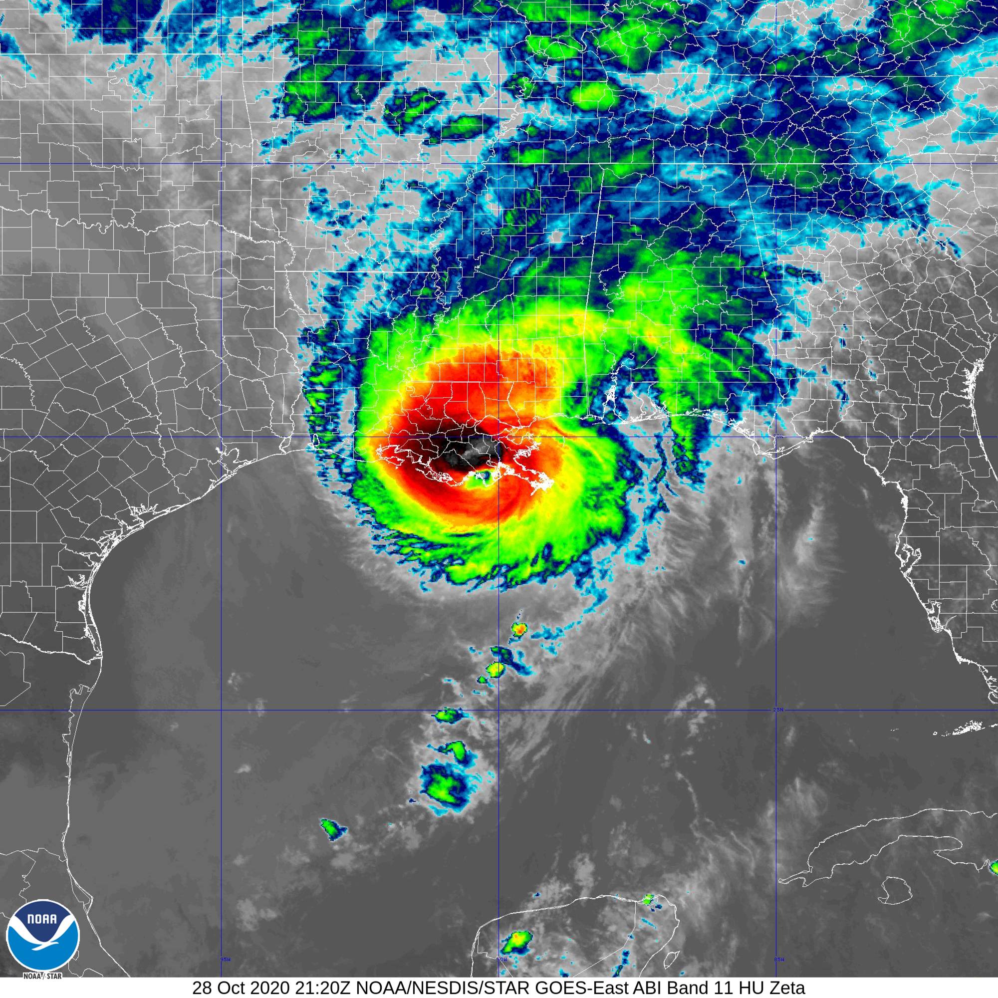
In order to support hurricane recovery activities and to improve future resiliency, Oceanweather (OWI) has produced “fast-response” hindcasts for Hurricanes Laura, Sally, Delta, and Zeta, all which have occurred this 2020 hurricane season. A detailed reanalysis of the conditions experienced in a land-falling hurricane are required in any ocean response modeling to provide critical guidance on the extent of the storm wave and surge inundation. OWI can provide wind, pressure, and/or OWI’s standard wave fields for these events.
As experts in providing meteorological forcing for ocean response modeling of extreme wind, wave and storm surge events, OWI has a long history of quickly responding to the need for hindcasts of recent or active tropical events. This expertise is also applied in long-term operational and storm hindcasts in public and private sectors around the globe.
In order to support hurricane recovery activities and to improve future resiliency, Oceanweather (OWI) is in the process of producing a “fast-response” hindcast for Hurricane Laura (2020). A detailed reanalysis of the conditions experienced in a land-falling hurricane are required in any ocean response modeling to provide critical guidance on the extent of the storm wave and surge inundation. OWI can provide wind, pressure, and/or OWI’s standard wave fields for this recent event.
As experts in providing meteorological forcing for ocean response modeling of extreme wind, wave and storm surge events, OWI has a long history of quickly responding to the need for hindcasts of recent or active tropical events. This expertise is also applied in long-term operational and storm hindcasts in public and private sectors around the globe.
Oceanweather (OWI) has started work on our second-generation South East Asia Fine hindcast (SEAFINE2) using new wind forcing and a unified grid setup (see figure below for the SEAFINE2 unified wind and wave model domain). The original SEAFINE Joint Industry Project (JIP) was first launched in 2006 as a follow on to the SEAMOS, SUS and SOUP JIPs all produced by OWI. The hindcasts included detailed reanalysis of typhoons and monsoons in the Southern and Northern South China Seas and ocean response modeling for wind waves and 3-D currents.
OWI’s initial efforts will be to produce an extension of the SEAFINE wind and wave deliverables for 2015-2019, and then extend the new modeling backwards to eventually replace the original SEAFINE results.
The Oceanweather Inc. (OWI) forecast group is now running an Arctic wave model domain covering 50N up to the North Pole, with a grid resolution of roughly 18 km. The model implements the parametric ice physics in WavewatchIII (WW3) using continuous and time-varying ice concentration inputs from the European Center for Medium Range Forecasting (ECMWF) forecast cycle. The wave model runs to a forecast horizon of 7 days, and outputs include fields of up to three wave trains. Full spectra points are available in addition to standard bulk wave parameters.
Identification of storm events in historical metocean data is a critical part of the derivation of return period extremes and in the understanding of harsh conditions experienced offshore. Peak conditions by variable (wind speed, wave height, current speed, etc.) stratified by forcing conditions (tropical, extra-tropical, monsoonal, etc.) and by direction are all typical requirements for operations and design of offshore structures. In order to develop design-level metocean hindcasts, Oceanweather faces the challenging task of reviewing and reanalyzing events over a large spatial and temporal domain to ensure peak conditions are well resolved and unbiased. To meet this challenge, a new storm clustering technique has been developed and applied in the latest Joint Industry Project: Brazil Offshore Meteorological and Oceanographic Study (BOMOS-2).
Oceanweather are pleased to announce that the GROW-FINE hindcasts East Coast (GFEC) and Caribbean (GFC-2) are now updated through 2019. For GFC-2 this includes the 2019 storms Dorian, Jerry, and Karen. For GFEC this includes Dorian as well as two (2) additional extratropical events in 2019.
Oceanweather Inc. (OWI) is pleased to announce the completion of Phase 1 of the BOMOS-2 JIP (Brazil Offshore Meteorological and Oceanographic Study Joint Industry Project).
BOMOS-2 is a comprehensive study of the wind and wave climate offshore Brazil improving upon the recent global ERA5 reanalysis in which extreme wind and wave events may not be well represented. This phase of the study consists of a hindcast for the continuous time period from 2000 – 2018, archived at a 30-minute time step and incorporating the expert wind-field analysis of over 70 storms using OWI’s proven IOKA approach. Storms were selected to be analyzed based on insitu and remote-sensed measurements, as well as with OWI’s novel peak identification and clustering methodology (used for the first time in this study).
December 2019 marked the 50th anniversary of the landmark doctoral dissertation by Dr. Vincent J. Cardone at New York University entitled “Specification of the Wind Distribution in the Marine Boundary Layer for Wave Forecasting”. Dr. Cardone’s dissertation introduced the first contemporary marine PBL model and showed how it could be applied to the practical problem of specification of marine surface wind fields to produce real-time wave forecasting. This approach was later refined and implemented at several national forecast centers around the world including NOAA/NWS National Centers for Environmental Prediction, U.S. Navy Fleet Numerical Oceanography Center, the Canadian Meteorological Centre, the Norwegian Meteorological Service, the Japanese Meteorological Agency, the Shanghai Forecast Center, and the New Zealand Meteorological Service. Dr. Cardone was an internationally recognized expert on the measurement of the winds over the ocean, synoptic scale analysis of wind fields, and on ocean wave modeling and forecasting. He received many awards in recognition of his accomplishments including the Oceanography Lifetime Achievement Award. Dr. Cardone was elected an AMS Fellow in 2001 in recognition of his contributions marine meteorology and oceanography.
A special session will be held at the upcoming American Meteorological Society (AMS) meeting, where OWI’s President Andrew T. Cox - along with Linwood Vincent, Dr. Don Resio, and Dr. Hans Graber - will speak in honor of Dr. Cardone. For more information, please visit https://annual.ametsoc.org/index.cfm/2020/.
Oceanweather (OWI), in collaboration with partner DHI, have updated the PERGOS-2 hindcast to include 2018. This brings the continuous/operational hindcast years to 1979-2018 and the storms hindcast to 1961-2018. PERGOS-2 will remain on the fine ~2 km grid for winds and waves and 0.025° (2.8 km) grid for hydrodynamic variables. A summary can be found here.
For further information regarding PERGOS-2 or any of our other speculative products, please contact Erin Harris via email at erinh@oceanweather.com or by phone at +1 203-661-3091.
Oceanweather’s (OWI) founder, Dr. Vincent Cardone, was honored for his contributions to oceanography and meteorology at the 2nd International Workshop on Waves, Storm Surges, and Coastal Hazards in Melbourne, Australia. Vince was a long-time attendee and presenter at the wave workshop series (16 in total) up until his passing in 2013. A full catalog of his workshop papers and presentation are available at www.waveworkshop.org.
Chairing the special session was Val Swail, the wave workshop founder and long-time friend of Vince. Val is retired from Environment Canada, but is very active in the Joint Commission on Marine Meteorology (JCOMM) and other organizations. The session included talks from Don Resio (this year’s recipient of the Vincent Cardone Memorial Prize for Marine Meteorology), Luigi Cavalari, Greg Holland, and OWI’s President, Andrew Cox.
Oceanweather has updated the GROW-FINE Mediterranean (GFMED) hindcast to include 2018. This brings the standard hindcast years to 1979-2018. GFMED will remain on the fine 0.125 degree/14 km and 0.025/3 km grids covering the Mediterranean Sea basin. The hindcast contains winds and waves for the entire grid (top figure, below) with a subsection also containing currents and water levels for the eastern portion (bottom figure, below).
The American Meteorological Society (AMS) will sponsor a special session in honor of Oceanweather’s founder, Vincent J. Cardone, at the 18th Symposium on the Coastal Environment to be held at the AMS 100th Annual Meeting this January in 2020 held in Boston, MA.
December 2019 marks the 50th anniversary of the landmark doctoral dissertation by Dr. Vincent J. Cardone at New York University (NYU) entitled “Specification of the Wind Distribution in the Marine Boundary Layer for Wave Forecasting”. Dr. Cardone introduced the first contemporary marine planetary boundary layer (PBL) model, and showed how it could be applied to the practical problem of specification of marine surface wind fields to produce real-time wave forecasting. Submissions are invited for presentations that focus on the historical perspective of wind/wave forecasting and hindcasting, including wave modeling advancements and their impact on the coastal environment building on top of Dr. Cardone’s landmark work over the past 50 years.
SciPy 2019, the 18th annual Scientific Computing with Python conference, was held over July 8-14 in the heart of Austin at the University of Texas. The annual SciPy Conference brings together over 800 participants from industry, academia, and government to showcase their latest projects, learn from skilled users and developers, and collaborate on code development. The schedule included tutorials, developer “sprints”, a poster session, plenary talks and mini-symposia.
The conference showcased the incredible possibilities in scientific computing that are being made reality when disparate communities work together in open and accessible ways. Among many amazing talks it was reinforced how this applies from institutional to inter-personal scales, and even in actual code that we use and collaborate on.
Oceanweather (OWI) was well represented at the 2019 Advanced Circulation Model (ADCIRC) User’s Group Meeting held at the US Army Corps Engineer Research and Development Center (ERDC) Coastal and Hydraulics Lab (CHL) over May 20-21, 2019 in Vicksburg, MS. Several of the talks applied OWI atmospheric forcing to produce detailed ocean storm surge and tidal simulations. OWI both implements the ADCIRC model for their hindcast products such as GOMOS, GROW-FINE Caribbean-2 (GFC-2), and GROW-FINE East Coast (GF-EC) as well participates as a collaborating member of the ADCIRC community. Recent collaboration efforts published in JGR: Oceans and Ocean Modelling are detailed on our Recent Publications page.
Oceanweather Inc. (OWI) is pleased to announce the latest update to the Meteorological Services of Canada (MSC) long-term North Atlantic wind and wave climatology known as MSC50. The MSC50 hindcast is applied by Canadian operators for offshore operability and design, and is the standard applied by Canadian regulatory agencies for permitting. The hindcast now extends for the period of 1954 to 2018 (65 years) and provides wind and wave time series in the Canadian East Coast Maritimes.
The Sentinel 3B altimeter was launched in April of 2018 and completed full commissioning in late fall of 2018. The measured data began flowing into Oceanweather’s forecast systems as of January 2019.
Data from altimeter satellites such as the Jason and Sentinel series are used to adjust the model forcing for the wave simulations. Data are both objectively and forecaster controlled for quality assurances and allow the forecaster to quickly see where the wave analysis is both higher or lower than measured. These areas can then be manually corrected to produce more accurate analysis and thus forecasted wave train simulations.
In order to support hurricane recovery activities and to improve future resiliency, Oceanweather (OWI) is in the process of producing a “fast-response” hindcast for Hurricane Michael (2018). A detailed reanalysis of the conditions experienced in a land-falling hurricane are required in any ocean response modeling to provide critical guidance on the extent of the storm wave and surge inundation. OWI can provide wind, pressure, and/or OWI’s standard wave fields for this recent event.
As experts in providing meteorological forcing for ocean response modeling of extreme wind, wave and storm surge events, OWI has a long history of quickly responding to the need for hindcasts of recent or active tropical events. This expertise is also applied in long-term operational and storm hindcasts in public and private sectors around the globe.
Oceanweather (OWI) are pleased to announce plans for a new Joint Industry Project (JIP) called Brazil Offshore Meteorological and Oceanographic Study - 2 (BOMOS-2). BOMOS-2 will serve as a follow-up to the previous similar JIPs: BOMOS and BOMOSHU. The JIP will include continous operational and storm hindcasts providing OWI’s standard wind and wave parameters for coastal regions of Brazil including Paraíba, Pernambuco, Alagoas, Sergipe, Bahia, Espírito Santo, Rio de Janeiro and São Paulo.
Oceanweather (OWI) has a long history of quickly responding to the need for hindcasts of recent or active tropical events. A detailed reanalysis of the conditions experienced in a land-falling hurricane are required in any ocean response modeling to provide critical guidance on the extent of the storm wave and surge inundation. Modeling efforts using OWI forcing are applied in hurricane recovery activities to support those affected, and in studies to improve future resiliency.
OWI has produced a “fast-response” hindcast for Hurricane Florence (2018). Users of this data may elect to receive wind, pressure and/or OWI’s standard wave fields. The domain will include two default grids: a coarse 0.25 degree grid covering 55W-99W, 5N-47N and a high resolution 0.05 degree grid covering the specific areas affected by the storm.
Oceanweather are pleased to announce the completion of the updated GROW-FINE Caribbean 2 (GFC-2) wind, wave, and hydrodynamic hindcast. Winds and waves were modeled on a nested set of grids with a resolution of 5.6km on the finest grid, and were run in a continuous operational period for years 1979-2017, incorporating overlapping reanalyzed tropical systems. Separate storm hindcasts of 374 tropical storms in years 1930-2017 have also been produced as part of the project, archived at a finer timestep than the continous modeling period. In addition to wind and wave parameters, the tropical storm hindcasts contain water surface elevation and 2D depth-averaged velocity variables generated by the state of the art ADCIRC numerical model using OWI’s lightweight version of the NOAA operational HSOFS mesh (HSOFSR), with output archived on the same grid points as the winds and waves.
Oceanweather are pleased to announce the completion of the updated GROW-FINE East Coast (GF-EC) wind, wave, and hydrodynamic hindcast covering the US Atlantic Ocean coastline. Winds and waves were modeled on a nested set of grids with a resolution of 5.6km on the finest grid, and were run in a continuous operational period for years 1979-2017, incorporating overlapping reanalyzed tropical systems. Separate storm hindcasts of significant tropical (1924-2017) and extra-tropical (1957-2017) storms have also been produced as part of the project using a finer archive timestep. In addition to wind and wave parameters, the tropical storm hindcasts contain water surface elevation and 2D depth-averaged velocity variables generated by the state of the art ADCIRC numerical model using OWI’s lightweight version of the NOAA operational HSOFS mesh (HSOFSR), with output archived on the same grid points as the winds and waves.
Oceanweather are pleased to announce the completion of the Gulf region PERGOS-2 hindcast. This update to the PERGOS hindcast has been run on a finer mesh over the years 1961-2017 (for storm hindcasts) and 1979-2017 (for the continuous operational hindcast). As with the original PERGOS, hydrodynamic variables are contained in the hindcast along with winds and waves.
Oceanweather are pleased to announce an update to GOMOS (Gulf of Mexico Oceanographic Study) for the years 2015-2017 in a version of the hindcast called GOMOS2017. In addition to these three (3) years, new variables Wind Gusts and Mean Zero-Crossing Period (TZ) will be included in the hindcast.
For further information on the costs associated with updating your GOMOS hindcast using GOMOS2017 results please contact Erin Harris via email at erinh@oceanweather.com.
Click here to learn about Brian’s history of surfing and his interest in meteorology in the most recent Swell Navigator Stories. For more information about the Swell Navigator App, go to swellnavigator.com.
Oceanweather are pleased to once again exhibit at the Offshore Technology Conference (OTC) in Houston, April 30 – May 3, 2018 at NRG Park. This is the 50th year of the conference and OWI’s 23rd year as an exhibitor. Please visit Oceanweather at Booth 2206 in NRG Center.
An evaluation of the latest European Centre for Medium-Range Weather Forecasts (ECMWF) reanalysis, known as the ERA5, is represented at the 2018 Waves in Shallow Environments (WISE) conference in Tel Aviv, Israel. Oceanweather (OWI) compared the ERA5 dataset against altimeter and buoy measurements from 2010 – 2016 using the 10-meter winds and significant wave height with focus on the wind forcing in the strongest tropical and extra-tropical events. Wind forcing has been shown to be a dominant source of error when applied in ocean response models for describing the peak events that drive design and operability in offshore and coastal applications and this informs potential users of deficiencies within the dataset.
Oceanweather (OWI) presented a replacement for their ADCIRC NWS-12 wind and pressure (also known as WIN/PRE) input format at the 2018 ADCIRC User’s group meeting. This new format (NWS-13) is based on NetCDF4, and supports arbitrary numbers of sub-grid overlays, sophisticated grid descriptions and storm-following moving grids matched with independent temporal descriptions to ensure sufficient spatial and temporal fidelity to capture the complex dynamics of a specific storm or set of storms.
Oceanweather are excited to once again exhibit at Oceanology International in London. This will be the eighth time as an exhibitor to the conference after the company’s founder, Dr. Vincent Cardone, was presented with the Oceanology International Lifetime Achievement Award in 2002. Please visit us at stand A20 at the Excel Center London.
In addition to our standard global winds and waves, Oceanweather also maintains a collection of various hindcast options not typically found in our standard hindcasts. GROW-MET, GROW-TIDE, and GROW-HYDRO are three of OWI’s low cost, add-on hindcast products many find useful as a way to fulfil requirements for detailed metocean design that go beyond winds and waves. Below is a listing with detail for each of these hindcast add-on options.
Oceanweather is pleased to announce our partnership with Swell Navigator. Swell Navigator is a new surf spot forecasting app developed by dedicated surf explorers. Oceanweather will be providing our expertise through standard global wind and wave forecast products. Surf spots, forecasts, and ideal conditions are fully personalized and customizable within the app. Swell Navigator allows you to build your personal surf spot database and organize it into custom surf lists. Share surf lists with your friends to score the most epic waves together.
An analysis of Hurricane Harvey (2017) was presented at the 1st Workshop on Waves, Storm Surges and Coastal Hazards held in Liverpool, UK. Harvey made landfall near San Jose Island on the Texas coast as a Category 4 storm on the Saffir-Simpson scale with one-minute winds of 115-120 knots. The storm devastated the coastal towns of Rockport and Fulton TX and dumped over 50 inches of rain in the Houston area. In order to critically assess wind, wave and surge damage both offshore and on the coast, a detailed analysis of the wind and pressure fields in Harvey were required for application in ocean response models.